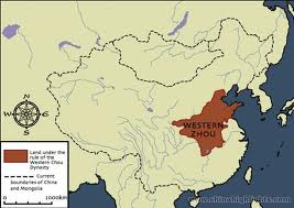
This is a map of the Zhou Dynasty. (1100-771BC) The Western Zhou was the 1st time period of the Zhou Dynasty, Western Zhou (as exampled above) and the Eastern Zhou(bottom), each name referred to the location of the capital during each time period. The Western Zhou came before eastern Zhou time period. The Western Zhou shaded in brown later expanded and gained much more land across the whole plain of the Yellow river thanks to the Duke of Zhou (Huang Di, also known as the yellow lord) who expanded the Zhou dynasty in the Eastern time period. The yellow River which is not very well presented on this map, starts in the middle of China, China is the area in the dashed lines. The yellow river was located north western of the Zhou dynasty. As you see the Eastern Zhou was much bigger than the western due to expanding. The Eastern Zhou is shaded in brown and the dashes are the borders of China. The previous Dynasty, the Shang dynasty map was much similar to the Western Zhou map. They both had the same amount of land and looked much alike.

No comments:
Post a Comment